
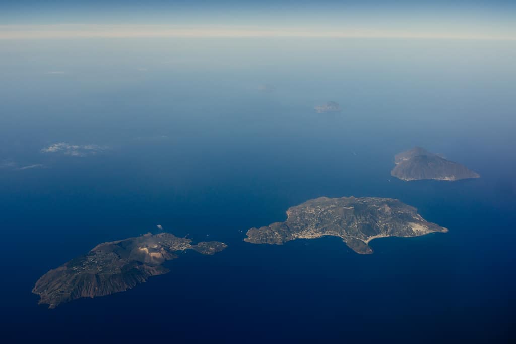
Italy · Tyrrhenian Sea
Aeolian Islands
Active volcanoes, black beaches and night passages to Stromboli.
Die Liparischen Inseln im Tyrrhenischen Meer, Italien · Photo: Wolfram Schubert · CC BY 2.0, Wikimedia Commons
The sailing area
Aeolian Islands · Italy · Tyrrhenian Sea
The seven Aeolian Islands north of Sicily are a UNESCO World Heritage Site and volcanically active. Stromboli regularly spews lava—an unforgettable spectacle from a boat at night.
Sheltered harbours are scarce, and many anchorages are deep and exposed. Departure ports include Capo d’Orlando, Portorosa and Milazzo. Lipari, Salina and Panarea offer mooring buoys and pontoons.
Nautical chart with anchorages
Nautical chart requires consent
To display the chart, map tiles are loaded from OpenStreetMap and OpenSeaMap. This transmits your IP address to their servers. Privacy policy
Anchorages in Aeolian Islands
Bays, harbours and mooring fields in Italy. Coordinates are approximate and not for navigation. Google Maps shows a place search, not a verified anchoring position.
- 1
Porto di Levante (Vulcano)
Bay · 38.418° N, 14.961° E
Sulphur springs and a mud bath on the beach.
Search in Google Maps - 2
- 3
Lipari – Marina Corta
Harbour · 38.464° N, 14.961° E
The islands’ main town, provisioning.
Search in Google Maps - 4
Santa Marina Salina
Harbour · 38.561° N, 14.872° E
Green island, famous for Malvasia wine.
Search in Google Maps - 5
Pollara (Salina)
Bay · 38.583° N, 14.809° E
Half-crater, filming location for “Il Postino”.
Search in Google Maps - 6
Panarea – Cala Junco
Bay · 38.625° N, 15.064° E
Rocky cove with a Bronze Age village.
Search in Google Maps - 7
Stromboli – Ficogrande
Bay · 38.807° N, 15.235° E
Anchoring beneath the active volcano.
Search in Google Maps - 8
- 9
Alicudi
Bay · 38.537° N, 14.357° E
The most secluded island, with donkeys as the only means of transport.
Search in Google Maps
Suggested itineraries
Volcano sailing trip
7 days · approx. 120 sm
With a night-time volcanic spectacle off Stromboli as the highlight.
- Portorosa
- Vulcano
- Lipari
- Panarea
- Stromboli
- Salina
- Filicudi
- Portorosa
Coordinates are approximate and do not replace an official nautical chart or an up-to-date harbour guide.
Passage planning for Aeolian Islands
If you're planning a sailing trip in Aeolian Islands you should familiarise yourself with the wind, weather and local conditions beforehand. The best time to visit is usually during the season June to September. The difficulty level for this sailing area is “Challenging” – so plan your daily legs to leave enough time for changes in the weather, breaks and relaxed anchoring.
Wind and weather
Typical conditions in this sailing area: Variable winds; the Mistral from the NW can build up a swell. Check the latest weather report and the forecast for the next few days every morning. Many bays only offer shelter from certain directions. Having an alternative anchorage up your sleeve makes any sailing trip much more relaxed.
Anchoring with a catamaran
A catamaran like our Lagoon 42 can reach shallower bays thanks to its shallow draught. Still, pay attention to the seabed: seagrass meadows are protected and provide poor holding. Sandy patches are the better choice. Let out enough chain, rig an anchor bridle and check that the anchor is holding securely after setting it.
Before casting off
For Italy get up-to-date nautical charts and a harbour guide, and find out about local fees, protected areas and regulations. The map and coordinates on this page are planning aids, but do not replace navigation on board.